English
  Türkçe
  italiano
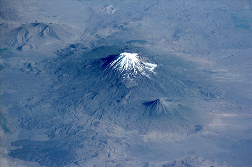
Mount Ararat
Mount Ararat | |
| |
Highest point | |
5,137 m (16,854 ft) | |
3,611 m (11,847 ft) [1] | |
379 km (235 mi) | |
39°42.113′N 44°17.899′E Coordinates: 39°42.113′N 44°17.899′E [2] | |
Naming | |
Native name | Ağrı Dağı (Turkish) |
Geography | |
Location in Turkey Show map of TurkeyShow map of AsiaShow map of EarthShow all | |
Location | Iğdır and Ağrı provinces, Turkey |
Region | |
| |
Geology | |
July 2, 1840 | |
Climbing | |
9 October [O.S. 27 September] 1829 | |
Designations | |
IUCN Category II (National Park) | |
Official name | Ağrı Dağı Milli Parkı |
Designated | 1 November 2004[3] |
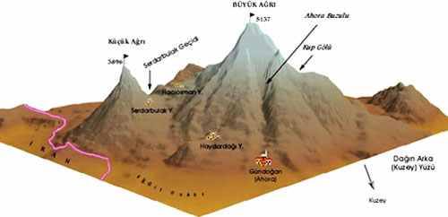
Mount Ararat (/ˈærəræt/ ARR-ə-rat;[4] Turkish: Ağrı Dağı; Armenian: Մասիս, romanized: Masis, and Արարատ, Ararat; Kurdish: Çiyayê Agirî) is a snow-capped and dormant compound volcano in the extreme east of Turkey. It consists of two major volcanic cones: Greater Ararat and Little Ararat. Greater Ararat is the highest peak in Turkey and the Armenian Highland with an elevation of 5,137 m (16,854 ft); Little Ararat's elevation is 3,896 m (12,782 ft).[5] The Ararat massif is about 35 km (22 mi) wide at ground base.[6] The first recorded efforts to reach Ararat's summit were made in the Middle Ages, and Friedrich Parrot, Khachatur Abovian, and four others made the first recorded ascent in 1829.
The mountain has been called by the name Ararat (in the West) since the Middle Ages, as it began to be identified with "mountains of Ararat" described in the Bible as the resting place of Noah's Ark, despite contention that Genesis 8:4 does not refer specifically to a Mt. Ararat. It is the principal national symbol of Armenia and has been considered a sacred mountain by Armenians. It is featured prominently in Armenian literature and art and is an icon for Armenian irredentism. It is depicted on the coat of arms of Armenia along with Noah's Ark.
Political borders
Mount Ararat forms a near-quadripoint between Turkey, Armenia, Iran, and the Nakhchivan enclave of Azerbaijan. Its summit is located some 16 km (10 mi) west of both the Iranian border and the border of the Nakhchivan exclave of Azerbaijan, and 32 km (20 mi) south of the Armenian border. The Turkish–Armenian–Azerbaijani and Turkish–Iranian–Azerbaijani tripoints are some 8 km apart, separated by a narrow strip of Turkish territory containing the E99 road which enters Nakhchivan at 39.6553°N 44.8034°E.
From the 16th century until 1828 the range was part of the Ottoman-Persian border; Great Ararat's summit and the northern slopes, along with the eastern slopes of Little Ararat were controlled by Persia. Following the 1826–28 Russo-Persian War and the Treaty of Turkmenchay, the Persian controlled territory was ceded to the Russian Empire. Little Ararat became the point where the Turkish, Persian, and Russian imperial frontiers converged.[7] The current international boundaries were formed throughout the 20th century. The mountain came under Turkish control during the 1920 Turkish–Armenian War.[8] It formally became part of Turkey according to the 1921 Treaty of Moscow and Treaty of Kars.[9] In the late 1920s, Turkey crossed the Iranian border and occupied the eastern flank of Lesser Ararat as part of its effort to quash the Kurdish Ararat rebellion,[10] during which the Kurdish rebels used the area as a safe haven against the Turkish state.[11] Iran eventually agreed to cede the area to Turkey in a territorial exchange.[10] [12] The Iran-Turkey boundary skirts east of Lesser Ararat, the lower peak of the Ararat massif.
As of 2004 the mountain is open to climbers only with "military permission". The procedure to obtain the permission involves submitting a formal request to a Turkish embassy for a special "Ararat visa", and it is mandatory to hire an official guide from the Turkish Federation for Alpinism. Access is still limited, even for climbers who obtain the necessary permission, and those who venture off the approved path may be fired upon without warning.[13]
Ararat (Western Armenian pronunciation: Ararad) is the Greek version[14] of the Hebrew spelling (אֲרָרָט;[15] RRṬ) of the name Urartu,[16] a kingdom that existed in the Armenian Highlands in the 9th–6th centuries BC. German orientalist and Bible critic Wilhelm Gesenius speculated that the word "Ararat" came from the Sanskrit word Arjanwartah, meaning "holy ground."[17] [18] Some Armenian historians, such as Ashot Melkonyan, link the origin of the word "Ararat" to the root of the endonym of the indigenous peoples of the Armenian Highland ("ar–"), including the Armenians.[19] [20] The mountain is known as Ararat in European languages,[21] [22] however, none of the native peoples have traditionally referred to the mountain by that name.[23] In classical antiquity, particularly in Strabo's Geographica, the peaks of Ararat were known in ancient Greek as Ἄβος (Abos) and Νίβαρος (Nibaros).[a] This mountain was not called by the name Ararat until the Middle Ages; early Armenian historians has considered Ararat to be in the area of Corduene.[28] [29]
The traditional Armenian name is Masis (Մասիս [maˈsis]; sometimes Massis).[30] [23] However, nowadays, the terms Masis and Ararat are both widely, often interchangeably, used in Armenian.[31] [b] The folk etymology expressed in Movses Khorenatsi's History of Armenia derives the name from king Amasya, the great-grandson of the legendary Armenian patriarch Hayk, who is said to have called the mountain Masis after himself.[36] [37] According to Russian orientalist Anatoly Novoseltsev the word Masis derives from Middle Persian masist, "the largest."[38] According to Armenian historian Sargis Petrosyan the mas root in Masis means "mountain", cf. Proto-Indo-European *mņs-.[37] According to archaeologist Armen Petrosyan it originates from the Māšu (Mashu) mountain mentioned in the Epic of Gilgamesh, which sounded like Māsu in Assyrian.[39]
The Turkish name is Ağrı Dağı [aːɾɯ da.ɯ], Ottoman Turkish: اغـر طﺎﻍ Ağır Dağ), i.e. "Mountain of Ağrı". Ağrı literally translates to "pain" or "sorrow".[21] [38] [40] [41] This name has been known since the late Middle Ages.[38] Greater and Lesser Ararat are known as Büyük Ağrı and Küçük Ağrı, respectively. The Persian name is کوه نوح, [ˈkuːhe ˈnuːh], Kūh-e Nūḥ,[7] literally the "mountain of Noah".[21] [30] The Kurdish name of the mountain is Çiyayê Agirî[42] [43] [t͡ʃɪjaːˈje aːgɪˈriː], which translates to "fiery mountain".[44]
Geography
Mount Ararat is located in the Eastern Anatolia Region of Turkey between the provinces of Ağrı and Iğdır, near the border with Iran, Armenia and Nakhchivan exclave of Azerbaijan, between the Aras and Murat rivers.[45] Its summit is located some 16 km (10 mi) west of the Turkey-Iran border and 32 km (20 mi) south of the Turco-Armenian border. The Ararat plain runs along its northwest to western side.
Elevation
Ararat is the third most prominent mountain in West Asia.
An elevation of 5,165 m (16,946 ft) for Mount Ararat is given by some encyclopedias and reference works such as Merriam-Webster's Geographical Dictionary and Encyclopedia of World Geography.[46] [47] [48] [49] However, a number of sources, such as the United States Geological Survey and numerous topographic maps indicate that the alternatively widespread figure of 5,137 m (16,854 ft) is probably more accurate.[50] [51] The current elevation may be as low as 5,125 m (16,814 ft) due to the melting of its snow-covered ice cap.[52]
Summit ice cap
The ice cap on the summit of Mount Ararat has been shrinking since at least 1957. In the late 1950s, Blumenthal observed that there existed 11 outlet glaciers emerging from a summit snow mass that covered about 10 km2 (3.9 sq mi).[53] At that time, it was found that the present glaciers on the summit of Ararat extend as low as an elevation of 3,900 meters (12,800 ft) on the north-facing slope, and an elevation of 4,200 meters (13,800 ft) on its south-facing slope.[53] Using pre-existing aerial imagery and remote sensing data, Sarıkaya and others studied the extent of the ice cap on Mount Ararat between 1976 and 2011.[42] [54] They discovered that this ice cap had shrunk to 8.0 km2 (3.1 sq mi) by 1976 and to 5.7 km2 (2.2 sq mi) by 2011. They calculated that between 1976 and 2011, the ice cap on top of Mount Ararat had lost 29% of its total area at an average rate of ice loss of 0.07 km2 (0.027 sq mi) per year over 35 years. This rate is consistent with the general rates of retreat of other Turkish summit glaciers and ice caps that have been documented by other studies.[54]
Blumenthal estimated that the snow line had been as low as 3,000 meters (9,800 ft) in elevation during the Late Pleistocene.[53] Such a snow line would have created an ice cap of 100 km2 (39 sq mi) in extent. However, he observed a lack of any clear evidence of prehistoric moraines other than those which were close to the 1958 glacier tongues. Blumenthal explained the absence of such moraines by the lack of confining ridges to control glaciers, insufficient debris load in the ice to form moraines, and their burial by later eruptions. Years later, Birman observed on the south-facing slopes a possible moraine that extends at least 300 meters (980 ft) in altitude below the base of the 1958 ice cap at an elevation of 4,200 meters (13,800 ft).[55] He also found two morainal deposits that were created by a Mount Ararat valley glacier of Pleistocene, possibly Wisconsinan (Last Glacial Maximum) age, downvalley from Lake Balık. The higher moraine lies at an altitude of about 2,200 meters (7,200 ft) and the lower moraine lies at an altitude of about 1,800 meters (5,900 ft). The lower moraine occurs about 15 kilometers (9.3 mi) downstream from Lake Balık. Both moraines are about 30 meters (98 ft) high. It is suspected that Lake Balık occupies a glacial basin.[55]
Geology
Mount Ararat is a polygenic, compound stratovolcano. Covering an area of 1,100 km2 (420 sq mi), it is the largest volcanic edifice within the region. Along its northwest–southeast trending long axis, Mount Ararat is about 45 kilometers (28 mi) long and is about 30 kilometers (19 mi) long along its short axis. It consists of about 1,150 km3 (280 cu mi) of dacitic and rhyolitic pyroclastic debris and dacitic, rhyolitic, and basaltic lavas.[5]
Mount Ararat consists of two distinct volcanic cones, Greater Ararat and Lesser Ararat (Little Ararat). The western volcanic cone, Greater Ararat, is a steep-sided volcanic cone that is larger and higher than the eastern volcanic cone. Greater Ararat is about 25 kilometers (16 mi) wide at the base and rises about 3 kilometers (1.9 mi) above the adjacent floors of the Iğdir and Doğubeyazıt basins. The eastern volcanic cone, Lesser Ararat, is 3,896 meters (12,782 ft) high and 15 kilometers (9.3 mi) across. These volcanic cones, which lie 13 kilometers (8.1 mi) apart, are separated by a wide north–south-trending crack. This crack is the surface expression of an extensional fault. Numerous parasitic cones and lava domes have been built by flank eruptions along this fault and on the flanks of both of the main volcanic cones.[5]
Mount Ararat lies within a complex, sinistral pull-apart basin that originally was a single, continuous depression. The growth of Mount Ararat partitioned this depression into two smaller basins, the Iğdir and Doğubeyazıt basins. This pull-apart basin is the result of strike-slip movement along two en-echelon fault segments, the Doğubeyazıt–Gürbulak and Iğdir Faults, of a sinistral strike–slip fault system. Tension between these faults not only formed the original pull-apart basin, but created a system of faults, exhibiting a horsetail splay pattern, that control the position of the principal volcanic eruption centers of Mount Ararat and associated linear belt of parasitic volcanic cones. The strike-slip fault system within which Mount Ararat is located is the result of north–south convergence and tectonic compression between the Arabian Platform and Laurasia that continued after the Tethys Ocean closed during the Eocene epoch along the Bitlis–Zagros suture.[5] [56] [57]
Geological history
Tectonic map of the Mediterranean and surrounding mountain ranges
During the early Eocene and early Miocene, the collision of the Arabian platform with Laurasia closed and eliminated the Tethys Ocean from the area of what is now Anatolia. The closure of these masses of continental crust collapsed this ocean basin by middle Eocene and resulted in a progressive shallowing of the remnant seas, until the end of the early Miocene. Post-collisional tectonic convergence within the collision zone resulted in the total elimination of the remaining seas from East Anatolia at the end of early Miocene, crustal shortening and thickening across the collision zone, and uplift of the East Anatolian–Iranian plateau. Accompanying this uplift was extensive deformation by faulting and folding, which resulted in the creation of numerous local basins. The north–south compressional deformation continues today as evidenced by ongoing faulting, volcanism, and seismicity.[5] [56] [58]
Within Anatolia, regional volcanism started in the middle-late Miocene. During the late Miocene–Pliocene period, widespread volcanism blanketed the entire East Anatolian–Iranian plateau under thick volcanic rocks. This volcanic activity has continued uninterrupted until historical times. Apparently, it reached a climax during the latest Miocene–Pliocene, 6 to 3 Ma. During the Quaternary, the volcanism became restricted to a few local volcanoes such as Mount Ararat. These volcanoes are typically associated with north–south tensional fractures formed by the continuing north–south shortening deformation of Anatolia.[5]
In their detailed study and summary of the Quaternary volcanism of Anatolia, Yilmaz et al. recognized four phases to the construction of Mount Ararat from volcanic rocks exposed in glacial valleys deeply carved into its flanks.[5] First, they recognized a fissure eruption phase of Plinian-subPlinian fissure eruptions that deposited more than 700 meters (2,300 ft) of pyroclastic rocks and a few basaltic lava flows. These volcanic rocks were erupted from approximately north northwest–south southeast-trending extensional faults and fissures prior to the development of Mount Ararat. Second, a cone-building phase began when the volcanic activity became localized at a point along a fissure. During this phase, the eruption of successive flows of lava up to 150 meters (490 ft) thick and pyroclastic flows of andesite and dacite composition and later eruption of basaltic lava flows, formed the Greater Ararat cone with a low conical profile. Third, during a climatic phase, copious flows of andesitic and basaltic lavas were erupted. During this phase, the current cones of Greater and Lesser Ararat were formed as eruptions along subsidiary fissures and cracks and flank occurred. Finally, the volcanic eruptions at Mount Ararat transitioned into a flank eruption phase, during which a major north–south-trending fault offset the two cones that developed along with a number of subsidiary fissures and cracks on the volcano's flanks. Along this fault and the subsidiary fissures and cracks, a number of parasitic cones and domes were built by minor eruptions. One subsidiary cone erupted voluminous basalt and andesite lava flows. They flowed across the Doğubeyazıt plain and along the southerly flowing Sarısu River. These lava flows formed black ʻaʻā and pāhoehoe lava flows that contain well preserved lava tubes.[5] The radiometric dating of these lava flows yielded radiometric ages of 0.4, 0.48 and 0.81 Ma.[59] Overall, radiometric ages obtained from the volcanic rocks erupted by Mount Ararat range from 1.5 to 0.02 Ma.[5]
Recent volcanic and seismic activity
The chronology of Holocene volcanic activity associated with Mount Ararat is documented by either archaeological excavations, oral history, historical records, or a combination of these data, which provide evidence that volcanic eruptions of Mount Ararat occurred in 2500–2400 BC, 550 BC, possibly in 1450 AD and 1783 AD, and definitely in 1840 AD. Archaeological evidence demonstrates that explosive eruptions and pyroclastic flows from the northwest flank of Mount Ararat destroyed and buried at least one Kura–Araxes culture settlement and caused numerous fatalities in 2500–2400 BC. Oral histories indicated that a significant eruption of uncertain magnitude occurred in 550 BC and minor eruptions of uncertain nature might have occurred in 1450 AD and 1783 AD.[60] [57] [58] [61] According to the interpretation of historical and archaeological data, strong earthquakes not associated with volcanic eruptions also occurred in the area of Mount Ararat in 139, 368, 851–893, and 1319 AD. During the 139 AD earthquake, a large landslide that caused many casualties and was similar to the 1840 AD landslide originated from the summit of Mount Ararat.[57] [58] [62]
1840 eruption
A phreatic eruption occurred on Mount Ararat on July 2, 1840 and pyroclastic flow from radial fissures on the upper north flank of the mountain and a possibly associated earthquake of magnitude 7.4 that caused severe damage and numerous casualties. Up to 10,000 people in the region died in the earthquake, including 1,900 villagers in the village of Akhuri (Armenian: Akori, modern Yenidoğan) who were killed by a gigantic landslide and subsequent debris flow. In addition, this combination of landslide and debris flow destroyed the Armenian monastery of St. Jacob near Akori, the town of Aralik, several villages, and Russian military barracks. It also temporarily dammed the Sevjur (Metsamor) Rive
Best Times to Climb Mount Ararat:
Ararat Mountain and Mount Damavand winter climbing dates 01 March-30 May -For summer climbing, 01 June 15 October is suitable -.Nuh Ararat Travel Agency